Neil Peart's News, Weather and Sports
Under The Marine Layer
NeilPeart.net, June 2009
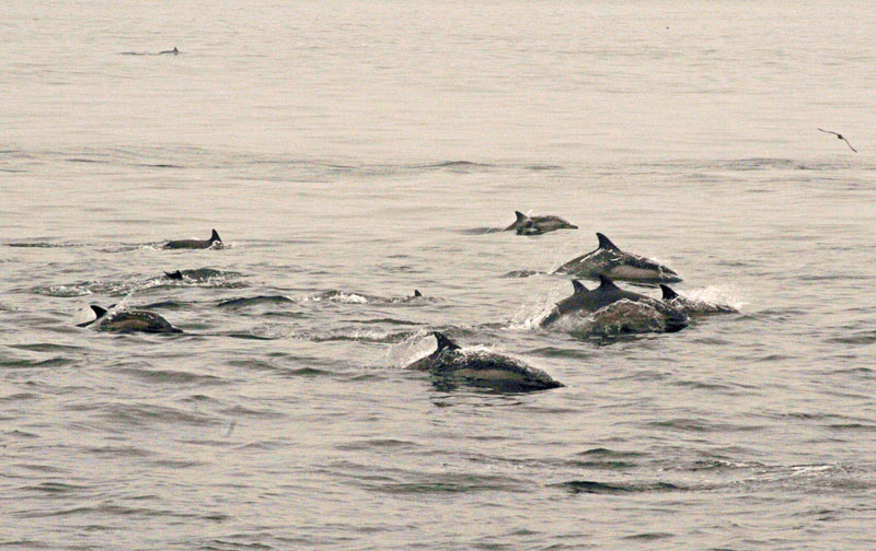
The obvious "marine layer" here is the surface of the Pacific Ocean, about ten miles out in the Santa Barbara Channel, off the coast of Southern California. Early one Saturday morning in May, the tour boat was on its scheduled run from Ventura to Santa Cruz Island, the largest island in the Channel Islands National Park, with a cargo of hikers, campers, kayakers, and birdwatchers. The captain shut down the engine, and the boat drifted silently in the middle of an enormous pod of dolphins - hundreds of dolphins, all around us, cutting the calm gray surface in every direction. Groups of six or eight at a time rose in synchronized arcs, a pattern repeated near and far and all around, like some fantastic water ballet. Raising cameras and binoculars, people moved slowly around the deck, in a kind of quiet reverence broken only by occasional half-whispers along the lines of "Wow!," and, "Look at that!"
The only comparable wildlife spectacle I have witnessed would be the teeming herds of antelopes, zebras, and wildebeest in the Serengeti, or the huge flocks of sandhill cranes and snow geese in Alaska, massing for their southward migration. Wildlife in such numbers are rarely seen in these times, and a sight like that catches the breath of a nature lover like me, or my friend Craiggie.
Craiggie is a keen and artful amateur photographer ("Dunkelkammer" is German for "darkroom"), and his opening portrait of a few of those dolphins is an evocative, luminous image - surely worth a thousand words. However, it is also true that bringing Craiggie and me to that boat off the coast of Southern California - painting the frame around that portrait - might take two thousand words.
The graceful dolphins and calm water are textured by the misty gray air over the ocean that morning - the true "marine layer." The term is often heard in Southern California weather reports, and refers to a "sandwich" of cool, moist air above the cold water, held down by a warmer layer above it. Despite Southern California's stereotype of sun, sand, surf and Endless Summer, the water along the California coast flows south from the cold Northern Pacific, and can be up to thirty degrees colder than the same latitude on the Atlantic shore, warmed by the Gulf Stream. Over land, the marine layer phenomenon becomes a "thermal inversion," a stagnant weather pattern that presses down a smoggy bubble over unlucky valleys like the Los Angeles Basin or Mexico City.
Along the coast, though, the marine layer is fresh ocean air, but it can linger for days, even weeks. Some residents disparage this weather pattern, calling it "May Gray" or "June Gloom," and they pine for the California sun to emerge in all its glory. Others among us are grateful for the relief offered by that marine layer. The misty air attenuates the heat that can become oppressive in late summer and fall, yet the thin overcast is not like the dark and gloomy fogs of, say, the Pacific Northwest. With no heavy clouds above, sunlight permeates the marine layer with a soft, pearly glow that often remains bright enough to make you squint and reach for your sunglasses.
 |
Garden in the June Gloom Full of singing birds |
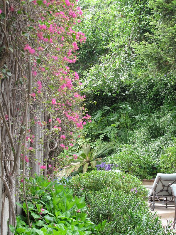
Vivid colors seem to jump out in that muted light - the pink and magenta bougainvillea on the walls of our house; a high tunnel of purple flowers on the jacaranda trees arching over the streets of Santa Monica; the yellow blossoms of the chaparral along the mountain roadsides. Distant sounds are dampened, making backyard birdsongs clear of ambient noise, and dry of any reverberation.
The song those birds are singing must be "In Praise of June Gloom," for it is a busy season in birdland: mating, nest-building, incubating, and baby-feeding. I would join the birds in that song of praise, for in 2009 I have been able to experience that time of year for almost the first time in the nine years I have lived in Southern California - usually away touring or recording in spring and early summer - and it has become my favorite season there.
And "season" is by no means an exaggeration, once you become attuned to the subtle, but no less far-reaching rhythms of this Mediterranean-like climate. If a desert is defined by receiving less than ten inches of rainfall per year, the Los Angeles area, a true semi-desert, averages less than fifteen inches. More than half of that rain falls in January, February, and March, while almost none of it falls in June, July, and August - thus May Gray and June Gloom come after the rains and before the drought, and so are the greenest months of the year. Even apart from the lush subtropical gardens, which of course are irrigated by distant rivers, the naturally arid chaparral hills are blooming in rich colors of green with delicate blossoms of yellow and blue. The tall white spears of a succulent aptly named Our Lord's Candle stand out on the hillsides like huge white flames, blooming only once before they die - in a true blaze of glory. According to a local botanist who studies our hiking trails, in winter only about ten or twenty species of plants are blooming, while in May there can be up to 200 varieties of flowers.
The marine layer's cool and shady weather pattern favors the hiker, the birdwatcher, the dogwalker, the bicyclist, the protectively dressed motorcyclist, the top-down motorist, or the driver of an old car with no air-conditioning. People like that - me - prefer cooler, hazy days to the hot, dry frying pan of August and September, or worse, the gritty rasp of the Santa Ana winds blowing from the inland deserts and through the congested suburbs of the Los Angeles Basin.
Yet those congested suburbs are broken up and surrounded by an unparalleled network of parks, from the San Gabriel Mountains to the northeast, to Griffith Park above Hollywood, which begins a chain of parkland that stretches west for many miles through the Santa Monica Mountains, including Topanga State Park, to the undeveloped coast north of Malibu and out to the eight islands of the Channel Islands National Park. Inland, the Santa Monica Mountains Conservancy protects more than 60,000 acres of chaparral woodlands, with miles of hiking trails, campgrounds and picnic areas, and a rich variety of wildlife, including deer, rabbits, coyotes, many kinds of birds and reptiles, even a few mountain lions.
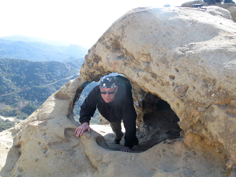 |
Through the eyes of Skull Rock, Topanga State Park |
With a nice long stretch of time at home in Southern California this year, I have been able to work on a good flow of prose writing, especially for the new cooking department, Bubba's Bar 'n' Grill. In addition, I have made it my mission to explore more of our local hiking trails, and found a good partner in my Web site designer and collaborator, Greg Russell. Greg and I first hiked together back in January, meeting in Topanga State Park and hiking to Skull Rock, a prominent outlook of sandstone eroded into the shape of its name. The view from there was a sweeping panorama of rounded mountains and fingered canyons carpeted in low shrubs, grasses, and live oaks (also called "evergreen oaks," as they don't drop their leaves in winter), all rich green after the early winter rains.
Fittingly, on that hike I was wearing my "skulls and roses" bandana (stage clothes from the Roll the Bones tour in 1992).
Greg and I are both avid motorcyclists, and we decided to develop a new sport called "motor-hiking," to combine the world-class motorcycling roads of the Santa Monica Mountains with access to various trailheads for scenic hikes. Over lunch in Topanga Canyon one day in March, Greg and I were discussing our next hike, and I wondered where the highest peak in those mountains was, and how we could get to it.
I did a little online research, and one foggy day in April - advance notice of the coming May Gray - Greg and I met at a trailhead on Yerba Buena Road, way north in Ventura County, to make that ascent. It was called Sandstone Peak, though the name was mysterious, because there was no sandstone on that mountain - it was a volcano. Just when I thought I had the geology around there figured out, I learned something new that turned it upside down - like the notion of volcanoes. I had thought those mountains were all sedimentary rock, ancient seabed pushed up by the collision of the Pacific plate with the North American plate - which continues to create the majestic Sierra Nevada to the east, as well as the area's frequent earthquakes - but apparently primordial volcanoes had contributed some igneous rock, too.
The mountain's name was another story. The area around Sandstone Peak was originally given to the Boy Scouts by a rancher, and the Scouts named the mountain after him, Mount Allen. However, the U.S. government's Board on Geographic Names did not allow a natural feature to be named for a living person, so the government gave it another name - after a kind of rock not found there. The Boy Scouts did put up a bronze plaque at the summit in honor of Mr. Allen.
Truth to tell, Sandstone Peak wasn't that impressive a summit - just over 3,000 feet - but it was the highest in the range, and that's what counted. Poring over trail maps and Google Earth (how nice to tilt the horizon on a hiking trail and see what the elevations look like), we planned an eight-mile loop that would take us to the summit, where the views were said to be spectacular - from the spread of the San Fernando Valley and the San Gabriels to the northeast, and west to the wide blue Pacific and the Channel Islands.
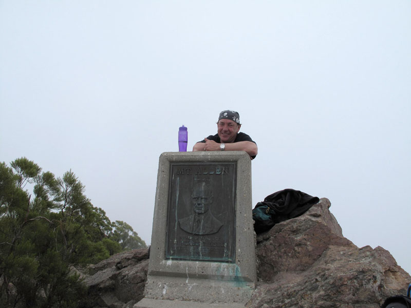 |
Sandstone Peak summit - laughing at the "view" |
But therein lay the one flaw in the atmosphere of May Gray and June Gloom: it's not great for views. That day was so foggy we could barely see thirty feet in front of us, and those expansive vistas were only hinted at by occasional rents in the clouds.
But again, the marine layer made for cool walking, especially uphill, and the soft pearly light had its own magic. The closed-in circle of the visible world drew us inward as we hiked along, and our conversation seemed more open and unguarded. Someday Greg and I will do that hike again, maybe in winter, which is also nice hiking weather, and more likely to be clear.
But having "conquered" the highest peak in the Santa Monica Mountains, and learned about the volcanic history of some of those peaks, I now knew that they stretched westward not only to the shore of the Pacific, but continued under the ocean all the way out to the Channel Islands, which were also volcanoes. In my season of local exploration, and a newly discovered ambition to be what I might define as a "nature writer," I was more than ever eager to visit those islands - an official national park, after all, and one of the very few in the United States I hadn't explored.
Yet it took a bird, the island scrub jay, to clinch the deal, and inspire Craiggie and me to plan that expedition - the boat trip to Santa Cruz Island that began this wandering tale.
From now on, it's all about Craiggie and me.
Craiggie and I had first met almost forty years before, back in our hometown of St. Catharines, Ontario. By chance, we were reacquainted earlier this decade, in Southern California, where Craiggie worked for the mighty Fox empire, in the "music legal" department. He had some dealings with Pegi at Rush's office about licencing one of our songs for a Fox show, and Pegi put Craiggie and me back in touch.
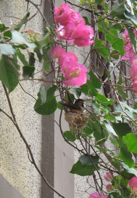
Craiggie lives with his wife and two daughters in a rambling old house, designed in the native Craftsman style I have long admired, in Pasadena. There Farmer Craiggie tends an impressive vegetable garden, as well as hosting large numbers of birds, both domestic and wild. For a long time, just about every Sunday Craiggie would e-mail me a photograph (to "Dr. O," for "ornithologist") of some bird that had visited his garden (or eaten one of his doves, like the peregrine falcon or the Cooper's hawk), wanting me to identify it. Those exchanges were amusing for both of us, but I encouraged Craiggie to get his own field guide, so he could enjoy looking up those birds for himself. He started sharing some of the bird sightings and identifications with his eleven-year-old daughter, Selena, and she developed an "eye for the birds," too. When I discovered a hummingbird nest in my backyard in May, I sent over a photo to Craiggie and Selena.
She's called an Anna's hummingbird (named by a French naturalist after Anna Masséna, Duchess of Rivoli - perhaps a patron, perhaps a lover; it suggests a romantic story), and here she is building her nest, shaping it by moving her body around ("frolicking," as I once described the behavior to my mother - to her great amusement) in the egg-cup-sized interior. The tiny woven bowl of grasses, small leaves, and dried flower petals was bound together with spider webs - an exquisite thing, though precarious looking on its thin branch of bougainvillea (to protect it from heavier predators, like snakes or bigger birds). As I spied on her from day to day, now calling her Anna, and trying not to disturb her too much, I saw that she had laid two pea-sized white eggs.
Around our house, there was a lot of nesting going on under the marine layer. A pair of black phoebes had moved in under the eaves, as they did every year, and constantly relayed bugs to feed their hatchlings; a pair of California towhees (perhaps the plainest, brownest birds ever) had a nest hidden deep in the bougainvillea; white-crowned sparrows built theirs in the hedge; and on the downhill side of the house, a pair of cliff swallows soared out over the canyon in long swooping forays for their insect baby-food.
At the same time, under that same marine layer, my wife Carrie was seven months pregnant. [Pause for sharp intake of breath and shiver of apprehension.] Our baby was growing and kicking, protected and insulated in its own oceanic fluid, its own marine layer. The anxious (not to say terrified) father kind of wished the baby could stay there, safe from harm, and not have to embark upon a life of menace and potential tragedy. He had lost before, and probably couldn't stand to lose again. People kept saying it was going to be all right, and he tried to keep telling himself that. Even in the June Gloom.
But like I said, there was a lot of nesting going on around our house ...
Back in February, when I was in Quebec - enjoying what might be my last long stay there for quite a while, as we await the Blessed Event - Craiggie wrote from Pasadena and told me Selena was doing a school project on a bird called the island scrub jay, and they wondered if I had anything to contribute. I'm still not sure how Selena came to pick that bird - a larger species of the common blue and gray California scrub jay, the island scrub jay is found only on the island of Santa Cruz, in the Channel Islands. I told Craiggie that I had never even seen one, and in fact, had never been to Channel Islands National Park. We decided to plan an expedition when I got back.
The females in our nests, mates and hatchlings alike, seemed to think there were better ways to spend a whole Saturday than taking a long boat ride to an uninhabited island and hiking around it for a few hours - so our plan didn't come together until May, and then it would just be Craiggie and me.
After I had checked out the schedules, Craiggie made the boat reservations for the next Saturday, May 16. We agreed to meet at the harbor, and a little before six a.m. that day I set out on my motorcycle, cruising north along the Pacific Coast Highway with the early morning soft and cool in pearly shades of May Gray. We met at Ventura Harbor before seven to check in, and at eight, boarded the tour boat with about thirty other people - campers, kayakers, a few families, and a small troop of Boy Scouts.
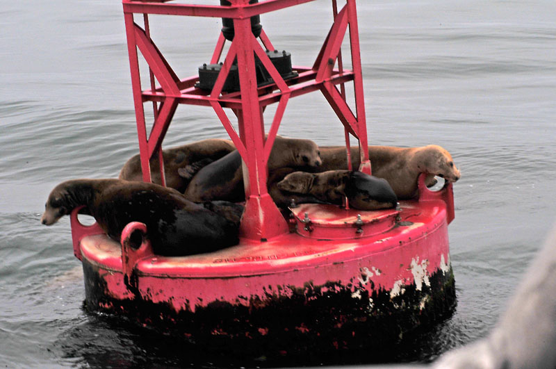
The marine layer seemed to suit these sea lions, too, lounging on a navigation marker as we motored toward Santa Cruz Island. Other sea lions and harbor seals frequently popped their canine heads out of the ocean beside us, singly or in pairs. In shallower water, massive kelp beds waved in the currents, part of an undersea forest that provided havens for multitudes of fish and crustaceans. Great numbers of seabirds filled the pale gray sky, wheeling around the boat in graceful flight, or floated on the still, almost oily looking dark gray water - cormorants, pelicans, ducks, shearwaters, terns, and gulls. Few sights in nature are more fetching than a flock of pelicans gliding inches above the water, in perfect symmetry, and without apparent effort. With all that, and the splendid vision of that dolphin ballet about halfway through the one-hour crossing, Craiggie and I were delighted, and encouraged, to see so much natural abundance, in an apparently healthy and productive environment.
We observed it all from our bench on the port side of the boat, a location I had recommended, to put us on the landward side as we approached the islands. Craiggie was amused by my story of where the word "posh" came from: In the days of British aristocrats traveling by sea to the Mediterranean, the prime cabin choice for views toward land was "port out, starboard home." We too would be traveling "posh."
Santa Cruz Island is three times the size of Manhattan, and is the largest of the eight Channel Islands. Stories from its modern history are suggested by some of the place-names, straight out of a Hardy Boys or Tintin book - Scorpion Ranch, Prisoners Harbor, Smugglers Cove, and Chinese Harbor. The first settlers were the Chumash Indians, but like elsewhere in coastal Southern California, they were displaced by Spanish ranchers, then nascent Americans. All of the islands were privately owned for many decades, mainly for ranching, and their landscapes were altered forever by great herds of cattle and sheep that nibbled away the vegetation in a devastating cycle of overgrazing and erosion.
Like other islands where pigs were introduced, from Hawaii to the Caribbean, the Channel Islands became overrun with escaped, feral pigs, among the most destructive of animals. Being pigs, after all, they root around everywhere like ravenous bulldozers, tearing up the landscape and devouring eggs, young birds, and delicate plants - which were also decimated by the introduction of rabbits, feeding and breeding in their tireless, prolific way.
The native flora was further transformed by the introduction of range grasses and thistles, eucalyptus trees, and an unexpectedly virulent "invasive species," fennel. Also found in some of the mainland canyons where I hike, the feathery green clumps of fennel are pretty, and have a delicious licorice perfume, but they crowd out the native plants - just as the fragrant yellow flowers of the Spanish broom along mountain roadsides in California, a sight and smell I love so much, are a threat to their native neighbors.
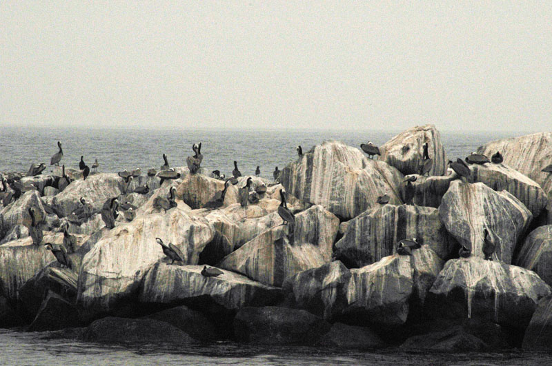
The guano-covered sea stacks around Santa Cruz Island came looming out of the fog, and the boat pulled up to the pier at Scorpion Ranch, where many of the passengers debarked. Craiggie and I stayed aboard until the next stop, Prisoners Harbor (I have written before about the U.S. government's Board on Geographic Names hating not only the names of living persons, but apostrophes: this is no exception). The name comes from a story that in the days of Spanish empire, a ship sailed north from Mexico to California with a cargo of convicts. None of the coastal communities would take them, so the captain marooned them on Santa Cruz Island, with a good supply of food and hunting and fishing equipment. When he returned at some later date (accounts vary), the convicts had disappeared (my original phrase was, "he found them gone"), and it was never determined if they had died there, or escaped by raft to the mainland.
As soon as our boat tied up at the pier and we climbed the ladder to the dock, I started looking through the gray mist at the eucalyptus trees and semi-desert shrubs, watching for an island scrub jay. By all accounts, the Prisoners Harbor area was the most likely location to see them, but - not to puncture any suspense this June Gloom Love Song may accidentally contain - ours would be the Quest for the Phantom Jay, and we never did see an island scrub jay. It didn't matter to Craiggie and me, but for Selena's sake, in commemoration of her school project, we would like to have seen one for her.
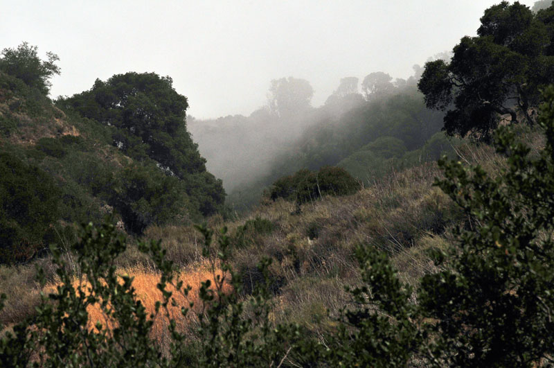
We shouldered our packs and headed uphill through a rounded landscape of low, grassy vegetation, punctuated by occasional live oaks in sheltered draws. The climb was steep and steady, following a dirt and gravel track called the Navy Road (hints at other uses those islands had been put to by the U.S. military, as bombing and shooting ranges). The marine layer still ruled the day, creating an ever-changing cloud of moist air that occasionally thickened to fog, or thinned to a curtain of mist that parted to admit brief patches of pale blue sky and stronger sunshine. Feeling the heat of that sun even for those short intervals, we appreciated the coolness of the mist when it returned. We agreed, "The marine layer rules!"
The road climbed for a mile or so, and continued very steep. Craiggie was an unpracticed hiker - his usual physical recreation was yoga and meditation - so under the unfamiliar aerobic strain, he began to fall behind. When climbing hills, whether on foot, cross-country skis, or even on a bicycle, every climber has to settle into their own pace, and slog along as best they can. I waited for Craiggie whenever the grade leveled out, or when we turned off onto the narrower Del Norte trail, and made sure he caught his breath and took a drink.
I told him, "When I'm on a motorcycle ride with someone who doesn't ride as ... 'enthusiastically' as I do, I always tell them the same thing: 'Look, I never mind stopping to wait for people - I only hate turning back, because that means I'm worried.'"
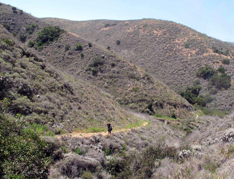 |
Craiggie gives the secret distress signal |
We agreed that I would watch behind me, in case Craiggie had to give the "secret distress signal" (from Team America: World Police - you raise your hands in the air and wave them around in wide-eyed, open-mouthed panic). I promised I would keep an eye on the time and distance, wait for him often, and watch for a nice shady place to have lunch.
Just at the point where the distress signal was received, I had spotted a grove of oaks with a shady patch of grass beneath. I waved Craiggie onward, trying to point to the shady grove where I would wait for him.
But he didn't come. Long minutes passed, until finally I went back down the trail (I mentioned how I hate that - because I worry), and found him gasping uphill from the last gully.
He looked up and said, "I think I've about reached ... that point."
I told him about the cool picnic spot just ahead, where we could take it easy and "have some lunchy-wunchy."
And oh, did we have some lunchy-wunchy. Farmer Craiggie unpacked and mixed a salad almost entirely from his garden, and also brought double chocolate brownies, fig newtons, trail mix, granola bars, and mixed fruit. From my pack came bottles of pink lemonade, sourdough rolls, Black Forest ham, havarti cheese, Grey Poupon mustard, mayonnaise, butter lettuce, and vine-ripened tomatoes, and I made a sandwich for each of us with my Swiss Army knife. As we spread our feast around us on the grass, I said, "I don't think we'll starve."
"Not for a few days, anyway," Craiggie replied.
And indeed, I had been thinking of what we would do if we were caught overnight on the island. I had never been on a hike that had to finish at a certain time, and it was a different, more pressured feeling. The one and only boat back to the mainland left at 3:00 p.m., and we were several miles from Prisoners Harbor now. If we happened to get lost, or even just twist an ankle to delay our return, what would happen?
We decided they'd probably send a helicopter for us, or at least a special park ranger boat. That sounded like fun, and we argued over which of us was going to throw himself down a cliff.
But when I glanced at my watch and saw that it was already nearly 1:30, I felt a little real concern. We were supposed to return to Prisoners Harbor by 2:45, and we had hiked over an hour, so we might be a little tight for time now. We repacked the remains of our lunch, and set off again. The clouds began to lift occasionally, letting the hot sun radiate across the magnificent views, and blaze on the shadeless trails, then they would close again and give us some relief.
Craiggie was still struggling, and I was trying to wait patiently, though struggling myself - against the urgency of getting to the dock in plenty of time. I kept him in sight, kept an eye on my watch, and was continually surprised at how long the Del Norte trail went on before we got back to the Navy Road. I'm sure Craiggie was, too.
Finally reaching that junction, we knew it was an easy downhill curve back to Prisoners Harbor, so we could relax and enjoy the experience again. Craiggie and I fell into step on the descent, making jokes from old episodes of Canada's "SCTV" (it's always nice for us ex-pats to share our comedic roots).
 |
Craiggie gives the secret distress signal |
I watched the birds more closely, spotting towhees, sparrows, and swallows, but still no jays. With the harbor in sight at last, and a few minutes to spare, we paused in the shade of a eucalyptus grove, leaning on an old fence and looking around. No jays.
Even back on the rounded stones of the beach, while we waited to board the boat, I studied the trees and brush all around, hoping for a glimpse - just to say we saw them.
Craiggie gives the secret distress signalBut, we didn't.
And it was all right.
Everything was all right, under the marine layer. The dolphins and sea lions in the ocean; the hummingbirds, towhees, sparrows, phoebes and their babies in my backyard; and the little baby growing inside Carrie. It was all going to be all right.
People kept telling me that, and I kept telling myself.
Never mind the June Gloom.